

This is the third of four webinars to share the results of vulnerability assessments conducted for regionally significant natural resources, some of which were identified by participants at two Adaptation Forum workshops hosted by the Southern Rockies Landscape Conservation Cooperative in 2016.
Resources
LCCs have produced a wealth of informational documents, reports, fact sheets, webinars and more to help support resource managers in designing and delivering conservation at landscape scales.

Date posted: July 25, 2017


In September 2016, partners convened a workshop in Tucson, Arizona to advance development of a Landscape Conservation Design in the Madrean Watersheds Pilot Area. This workshop was the first in-person convening for Landscape Conservation Design specific to this pilot area. The workshop provided a structured, collaborative forum for articulating the planning context and developing foundational components of a Landscape Conservation Design.
Date posted: July 24, 2017
The Eastern Mojave was selected as one of three Landscape Conservation Design pilot areas in early 2016. Landscape Conservation Design (LCD) is a process that identifies, develops and strengthens large-scale collaborative relationships. It produces information and tools needed by partners to meet common conservation goals by identifying important social values, resources, and stressors across a geography that transcends jurisdictional boundaries.
Date posted: July 18, 2017

The 2016 annual report is organized to report achievements and progress in implementing the GCPO LCC's five long-range strategies:
Date posted: July 18, 2017

This is the second of four webinars to share the results of vulnerability assessments conducted for regionally significant natural resources, some of which were identified by participants at two Adaptation Forum workshops hosted by the Southern Rockies Landscape Conservation Cooperative in 2016.
Date posted: July 12, 2017

This is the first of four webinars to share the results of vulnerability assessments conducted for regionally significant natural resources, some of which were identified by participants at two Adaptation Forum workshops hosted by the Southern Rockies Landscape Conservation Cooperative in 2016.
Date posted: July 11, 2017

This one-page double-sided flyer provides an introduction to the Upper Midwest and Great Lakes LCC and identifies the benefits of joining the community.
Date posted: June 28, 2017

This one-page double-sided flyer provides an introduction to the Plains and Prairie Potholes LCC and identifies the benefits of joining the community.
Date posted: June 28, 2017

This slide library, provided by the Midwest Perennial Forage Working Group, originated from a 2015 project that produced a series of six webinars for grazing educators in the Upper Mississippi River Basin. Top grazing educators from Illinois, Iowa, Minnesota, and Wisconsin developed the webinar content and delivered the presentations, sponsored by MPFWG and the Pasture Project of Wallace Center at Winrock International. Once the webinar series was complete, educators involved agreed to make their presentation slides available to other educators.
Date posted: June 27, 2017

A research study entitled "Open Pine Habitat: Desired Ecological States Provided by Managed Forests" was jointly sponsored by the Gulf Coastal Plains & Ozarks Landscape Conservation Cooperative and Mississippi State University from 2014 to 2016. The principal investigator was Dr. Ray Iglay, MSU. The project evaluated the extent to which planted pine can provide desired ecological states for wildlife species, using a literature review and meta-analyses.
Date posted: June 27, 2017

This brief report highlights the major accomplishments of the Eastern Tallgrass Prairie LCC in 2016 and 2017 and features insights regarding the value of collaboration from Steering Committee co-chairs and membership, as well as the direction of the LCC going forward.
Date posted: June 22, 2017

This is a case study developed to demonstrate how one of the innovative products developed by the Gulf Coastal Plains & Ozarks LCC for its partners assesses a wide variety of floodplain and river-associated habitats and is being used by numerous conservation partners.
Date posted: June 17, 2017
The SRLCC Steering Committee recognizes the need and importance of increasing tribal engagement efforts and formed an ad-hoc Tribal/Cultural Resource Work Group. The work group was tasked with developing an SRLCC Tribal Engagement Strategy. The strategy defines LCC investment areas to support tribal resource management efforts.
Date posted: June 15, 2017
Date posted: June 13, 2017
This group is a geospatial community of practice for identifying the resources, capabilities, and capacity to respond to the needs and requirements of the GCPOLCC.
It has met several times over the history of the LCC, with a large (~65) and changing set of participants. The group first met in 2011 to introduce the LCC to potential geomatics collaborators. In June and December of 2014 the group held virtual meetings, and a key focus was the set-up of the Conservation Planning Atlas.
Date posted: June 13, 2017

Beginning in 2016, all recorded GCPO LCC webinars are now available at our YouTube Channel:
https://www.youtube.com/channel/UC7V_OhUZns9FieFqUZ3URcw/
Webinars recorded prior to 2016 are available to play directly via Webex:
Date posted: June 9, 2017
This policy comes from Chapter 5 of the USFWS National Wildlife Refuge Planning handbook.
Date posted: June 8, 2017

This is a good overview factsheet that describes the Gulf Coastal Plains & Ozarks LCC and its work.
Date posted: June 8, 2017

This factsheet summarizes five projects supported and coordinated by the LCC that focus on assessing the attributes of landscape patterns and forest conditions that make open pine beneficial to wildlife (including managed pine) and developing tools to assist landowners with forest management/incentive decisions.
Date posted: June 8, 2017

This 8-pager provides an overview of the coordinated and strategic portfolio of conservation research projects that have been funded by four Landscape Conservation Cooperatives along the Gulf of Mexico: the Gulf Coast Prairie, Gulf Coastal Plains & Ozarks, South Atlantic, and Peninsular Florida LCCs.
Date posted: June 8, 2017

These two factsheets provide a summary of information about the Conservation Planning Atlas and why it was developed, as well as examples of how people are using the tool.
Date posted: June 8, 2017
The GCPO LCC prepared Ecological Assessments of 9 priority habitat systems as the basis for its "State of the GCPO" report as well as development of its Conservation Blueprint. The Assessments use existing LCC-wide digital geospatial datasets to quantify expert-defined metrics of habitat quality.
Date posted: June 8, 2017

The GCPO LCC prepared Ecological Assessments of 9 priority habitat systems as the basis for its "State of the GCPO" report as well as development of its Conservation Blueprint. The Assessments use existing LCC-wide digital geospatial datasets to quantify expert-defined metrics of habitat quality. The Assessments inform the LCC's Landscape Conservation Design process, which spatially depicts priority sites and habitats for inclusion in a habitat conservation network across the region and across the Southeast.
Date posted: June 8, 2017

Presenters: Cami Dixon, U.S. Fish and Wildlife Service and Kristine Askerooth, U.S. Fish and Wildlife Service, Tewaukon National Wildlife Refuge
Date posted: June 8, 2017

This is the original charter developed in 2012 to guide the work of the LCC's Adaptation Science Management Team or ASMT.
Date posted: June 7, 2017

The Great Northern LCC is pleased to provide its 2016 Annual Report. By working across jurisdictions and boundaries, the partnership made great strides on landscape conservation issues to benefit people and wildlife. The report provides highlights under four themes:
- A Growing Partnership
- Supporting Partners for a Shared Vision
- Connecting for Conservation
- Investing in Science
Date posted: June 6, 2017

The Southern Rockies LCC is pleased to provide its 2016 Annual Report. The report highlights the work of the Steering Committee, the collaborative efforts in the Green River Basin, Four Corners, and Upper Rio Grande focal areas, science project products, and communications.
Date posted: June 6, 2017

Presenters: William T. Flatley, Dept. of Geography, University of Central Arkansas; Frances C. O’Donnell, Dept. of Civil Engineering, Auburn University
Co-authors: Peter Z. Fulé, School of Forestry, Northern Arizona University; Abraham E. Springer, School of Earth Sciences and Environmental Sustainability, Northern Arizona University
Date posted: June 5, 2017

On May 10, 2017, Indiana University President Michael A. McRobbie announced that IU will invest $55 million to help Indiana develop actionable solutions that prepare businesses, farmers, communities and individuals for the effects of ongoing environmental change.
Date posted: May 22, 2017

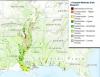
Local and regional organizations and agencies have together created a DRAFT Lower Wabash Strategic Framework to support a landscape conservation design to protect and improve habitats, working lands, and ecosystem services and functions, and provide benefits for wildlife and water quality locally and also downstream through the Mississippi River Basin and ultimately the Gulf of Mexico.
Date posted: May 22, 2017

This strategic plan positions ETPBR LCC members as leaders for regional conservation, identifies the natural resources challenges the LCC is up against, and sets forth a vision, mission and guiding principles to encourage growth and maturity for the partnership.
Date posted: May 18, 2017

Presenter: Pete Bauman, Range Field Specialist, South Dakota State University Extension
Date posted: May 10, 2017

Downloadable poster of the LCC Network's Vision.
Date posted: May 5, 2017
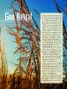
This article reports on an LCC-funded research project conducted by Iowa State University, quantifying the wildlife benefits of using prairie grass to produce clean, renewable natural gas.
Date posted: May 4, 2017

Access the GCPO LCC Projects Database
The GCPO LCC uses ScienceBase as a Project Database to track all work products developed by research institutions and investigators under agreements with the LCC, as well as significant accomplishments and work products developed by staff.
Explanation of key Project Database functions
Date posted: May 3, 2017

Access the Conservation Planning Atlas
The CPA is a science-based mapping platform where conservation managers and LCC members can go to view, retrieve, and perform analyses on spatial information with specific conservation goals in mind. Three portals have been created for the LCC network in the Southeast:
Date posted: May 3, 2017

These tools include maps that estimate the amount of milkweed present in metropolitan areas (baseline milkweed density) and maps that estimate the potential increase in the number of milkweed stems under different conditions (scenario planning). These maps allow the impact of particular conservation practices to be visually assesed, which in turn can inform how conservation priorities can be set.
Date posted: May 1, 2017

The Urban Monarch Conservation Guidebook is intended to support the efforts of people like city planners and conservation practitioners who are interested in identifying the best places and methods to create people- and pollinator-friendly habitat on the ground in urban areas. All you need to use the Guidebook is a motivation to do something for monarchs, some familiarity with how city space is organized, and comfort with using maps (or know someone who is comfortable).
Date posted: May 1, 2017

The GCPO LCC prepared Ecological Assessments of 9 priority habitat systems as the basis for its "State of the GCPO" report as well as development of its Conservation Blueprint. The Assessments use existing LCC-wide digital geospatial datasets to quantify expert-defined metrics of habitat quality. The Assessments inform the LCC's Landscape Conservation Design process, which spatially depicts priority sites and habitats for inclusion in a habitat conservation network across the region and across the Southeast.
Date posted: April 28, 2017

Date posted: April 28, 2017

This is the second edition of the GCPO LCC communications strategy, reflecting updates to communications practices and an expanded set of audiences, communications activities, and goals that reflect the maturing nature of the GCPO LCC in achieving its mission. New developments since the 2012 Communications Strategy include development and the beginning stages of assisting with implementation of a conservation blueprint for the entire geography, and via the Southeast Conservation Adaptation Strategy, for the entire Southeast region.
Date posted: April 28, 2017

The Nature of Americans is a national initiative to understand and connect Americans and nature. This report details insights, major findings, and recommendations for the United States as a whole. It draws from conversations, interviews, and surveys with nearly 12,000 Americans and contains five chapters:
- Introduction and methods
- Adults
- Children and parents
- Race, ethnicity, and other demographic differences
- Major findings and recommendations
Date posted: April 27, 2017